The Best Guide To Zion national Parks Trails and biking.
Epic 1-2 DAy Road Trips from Zion to Explore Hidden Gems Off the Beaten Path!
1 DAy ROAD TRIP Includes Stops At
Observation Point / Sand Caves / BUCKSkin Gultch / White Pockets / Water CAnyon Winery
1 Day BuckSKin Gultch
This stunning road trip winds through Zion National Park, Kanab’s hidden caves, the Vermilion Cliffs, Buckskin Gulch, and White Pocket, with stops for great food and wine along the way. You’ll experience some of the most remote and otherworldly landscapes in the Southwest, where sandstone cliffs, slot canyons, and swirling rock formations tell a story millions of years in the making.
Route Overview:
Total Distance: ~400 miles round-trip
Best Time to Go: Spring & Fall (cool temps, fewer crowds)
Best For: Hikers, photographers, and geology lovers
Stop 1: Observation Point (Zion National Park, UT)
Hike: East Mesa Trail to Observation Point (6.7 miles, moderate)
Why Go? Offers one of the best panoramic views of Zion Canyon, sitting 700 feet higher than Angel’s Landing!
Geological Feature: The viewpoint rests atop Navajo Sandstone, which was once a massive desert covered in ancient dunes.
Pro Tip: This trail avoids the crowds of other Zion hikes and offers breathtaking views.
Stop 2: Sand Caves (Kanab, UT)
Hike: Short but steep scramble (0.5 miles, moderate)
Why Go? These man-made caves glow with an orange and red hue when the sunlight hits.
Geological Feature: Carved into Entrada Sandstone, the same rock that forms Arches National Park.
Pro Tip: The rock can be slick—wear good hiking shoes.
Stop 3: Escobar’s Mexican Restaurant (Kanab, UT)
Why Go? Locally loved for authentic Mexican food—try the smothered burritos!
Best For: A delicious break before heading into the wilderness.
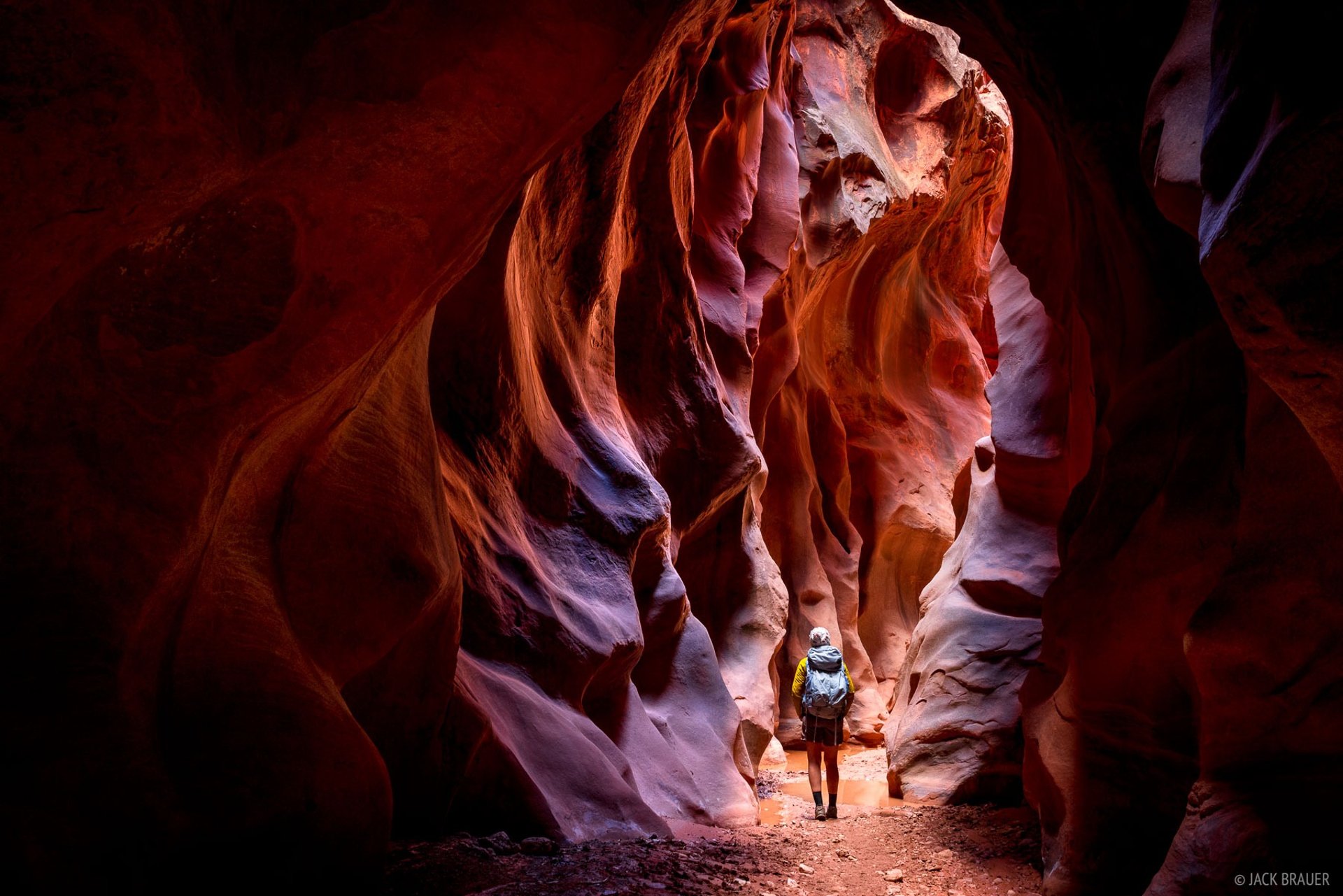
Stop 4: Buckskin Gulch – The Longest Slot Canyon in the World
Hike: Wire Pass to Buckskin Gulch (4–6 miles, moderate)
Why Go? At over 20 miles long, Buckskin Gulch is the deepest and longest slot canyon on Earth.
Geological Feature: Carved by flash floods, the walls tower nearly 500 feet above you.
Pro Tip: Always check the weather—this canyon is notorious for dangerous flash floods.
Stop 5: White Pocket (Vermilion Cliffs, AZ)
Hike: White Pocket Loop (1–2 miles, easy)
Why Go? This remote rock wonderland looks like a swirled marble cake!
Geological Feature: The strange formations were shaped by ancient dunes twisting under extreme geologic pressure.
Pro Tip: Requires a high-clearance 4x4 vehicle or a guided tour.
Stop 6: Jacob Lake, AZ (Gateway to the Grand Canyon North Rim)
Must-Try: Jacob Lake Inn’s Famous Cookies
Why Go? A cozy mountain lodge famous for its homemade cookies and milkshakes.
Bonus Detour: If time allows, visit the Grand Canyon’s North Rim, which is cooler, less crowded, and equally stunning.
Stop 7: Water Canyon Winery (Hildale, UT)
Why Go? A hidden gem in the Utah desert, offering handcrafted wines with incredible mountain views.
Best For: Unwinding after a long day of hiking.
Final Stop: Virgin, UT (Return Home)
Bonus Detour: Grafton Ghost Town (Near Virgin, UT)
Why Go? This Old West ghost town was featured in Butch Cassidy and the Sundance Kid.
Final Thoughts
This road trip is a dream for hikers and adventure seekers, taking you from the towering cliffs of Zion to the hidden gems of the Vermilion Cliffs. The landscapes here have been sculpted by millions of years of wind, water, and time, creating some of the most surreal scenery on Earth.
1 DAy ROAD TRIP Includes Stops At
Bryce Canyon / Duck Creek Village / BRian head / Cedar Breaks monument / KOLOB CANYON/
1 Day Bryce Canyon
This incredible road trip not only takes you through some of Southern Utah’s most iconic landscapes but also offers an opportunity to explore unique geological formations shaped over millions of years. From the wind-carved hoodoos of Bryce Canyon to the lava flows in Duck Creek, each stop on this route showcases the fascinating geological history of the region. Here's a breakdown of the geological features you'll encounter:
Route Overview:
Total Distance: ~250 miles round-trip
Best Time to Go: Late spring to early fall (summer offers wildflowers & cooler mountain air)
Best For: Hikers, nature lovers, geology enthusiasts, and anyone who wants to see the diversity of Southern Utah's landscapes.
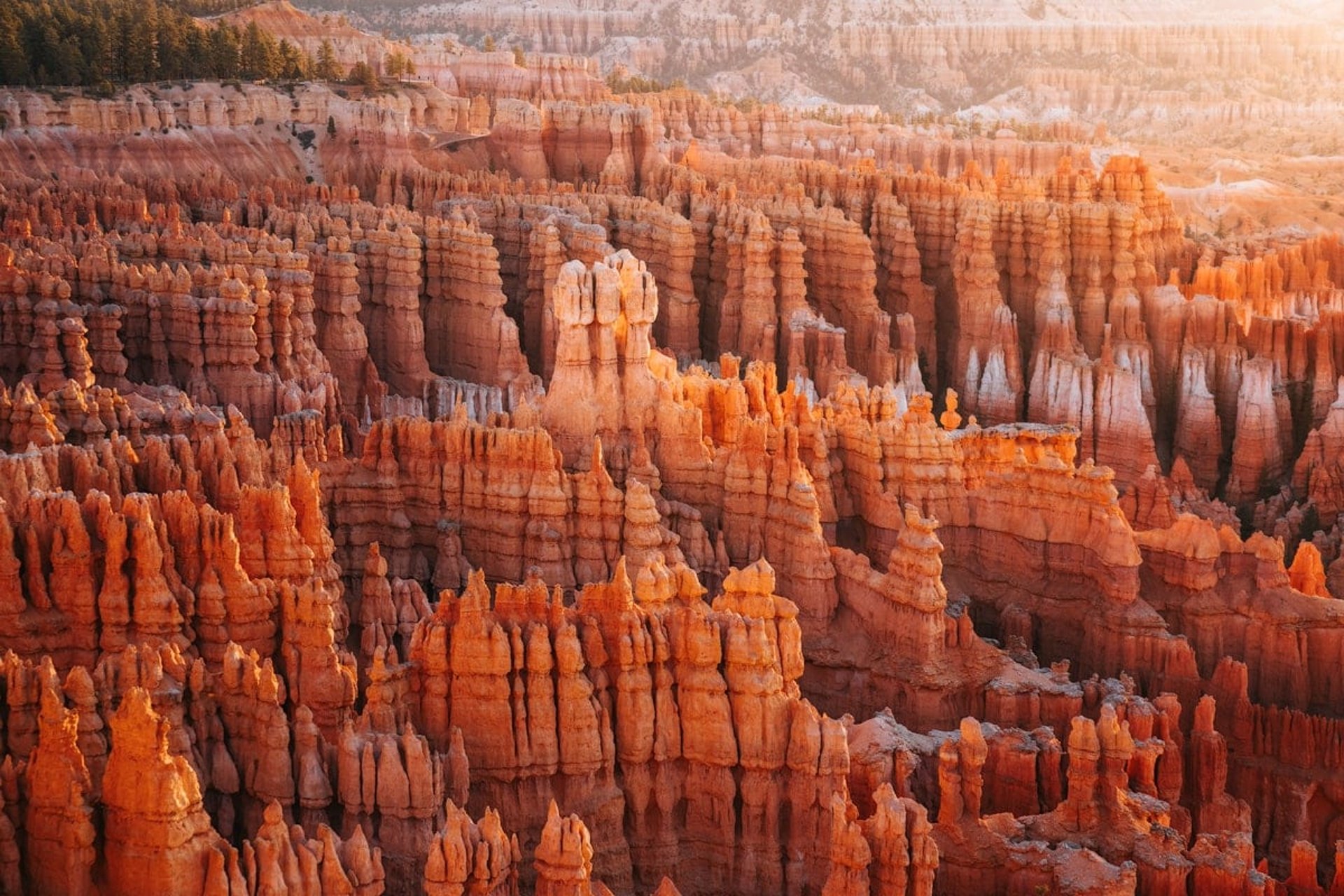
Stop 1: Bryce Canyon National Park – Sunrise Point
Hike: Queen’s Garden & Navajo Loop Trail (2.9 miles, moderate)
Geological Feature: Bryce Canyon is known for its hoodoos, tall, thin spires of rock that were formed by the freeze-thaw cycle. Water seeps into cracks in the rock, and when it freezes, it expands, breaking the rock apart. Over thousands of years, this process carved out intricate formations in the soft, layered sedimentary rock that makes up the canyon. The red, orange, and pink hues come from iron oxides in the rock, which oxidize when exposed to oxygen.
Pro Tip: Sunrise is the best time to witness the canyon's vibrant colors as the first light hits the hoodoos, casting long shadows and accentuating the rock layers.
Stop 2: Duck Creek Village, UT
EAT at a Local Restuarant
Geological Feature: Duck Creek Village lies on the Markagunt Plateau, which was formed by volcanic activity. The surrounding land is littered with lava tubes and pahoehoe lava flows. The area is home to Mammoth Cave, a lava tube cave formed when lava once flowed through it, leaving behind empty spaces. You can explore some of these ancient lava formations as you drive or hike the region.
Pro Tip: Check out the Lava Flow Overlook for a great view of the ancient volcanic fields.
Stop 3: Brian Head Resort (Utah’s Highest Ski Town)
Altitude: 9,800 feet
Geological Feature: Brian Head lies on the Markagunt Plateau, a result of volcanic activity from around 10-12 million years ago. The plateau is made up of volcanic rocks such as basalt, which gives the area its rugged appearance. The region’s highest peak, Brian Head, is made of tuff, a soft, porous volcanic rock that forms from the ash and debris of explosive volcanic eruptions.
Pro Tip: Take the Giant Steps Express Lift to the top for views of the basalt rock formations that shaped the plateau.
Stop 4: Cedar Breaks National Monument (Mini Bryce Canyon at 10,000 ft!)
Hike: Alpine Pond Loop (2 miles, easy)
Geological Feature: Cedar Breaks is often referred to as a "mini-Bryce" because of its similar hoodoos and canyon-like features. However, Cedar Breaks is located at a much higher elevation. The hoodoos in Cedar Breaks are carved from limestone and dolomite, which are more resistant to erosion than the sandstone in Bryce Canyon. The area also features ancient bristlecone pine forests that grow in rocky, calcareous soil. The geological formation of the plateau here is the result of tectonic uplift and erosion over millions of years.
Pro Tip: The contrast between the bright red cliffs and the green alpine meadows is stunning, especially during the wildflower season in July.
Stop 5: Kolob Canyons Viewpoint (Zion National Park’s Overlooked Side)
Hike: Timber Creek Overlook (1 mile, easy)
Geological Feature: Kolob Canyons is part of the Zion National Park complex, and its towering cliffs are made of Navajo Sandstone. This sandstone was deposited by ancient sand dunes over 190 million years ago during the Jurassic Period. The sedimentary layers were compacted and hardened into rock, and over time, erosion sculpted the cliffs and canyons. The red and orange hues are a result of iron oxide in the sandstone.
Pro Tip: Kolob Canyons is less visited than the main part of Zion, making it an excellent spot for a peaceful hike or sunset.
Final Stop: Virgin, UT (Return Home)
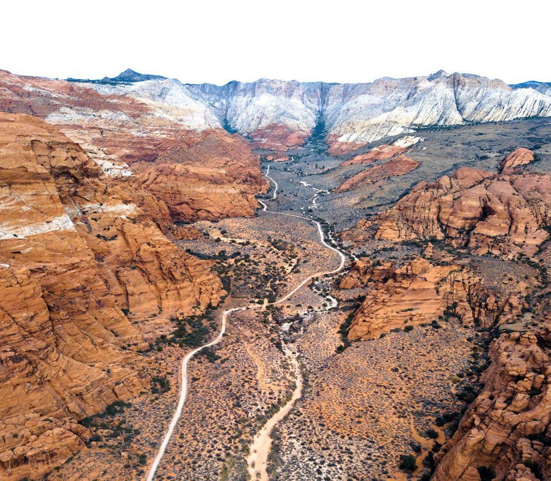
Bonus Detour: Kolob Terrace Road (Near Virgin, UT)
Geological Feature: The Kolob Terrace area sits on a tectonically uplifted plateau that offers incredible views of the red rock cliffs of Zion. The region has a combination of sedimentary rock layers and igneous intrusions (from ancient volcanic activity). You can spot Paleozoic fossils in some of the exposed rock layers.
Pro Tip: Kolob Terrace Road offers some of the best views of Zion’s mountain peaks, especially at sunrise and sunset.
Final Thoughts
This road trip is an excellent way to explore the rich geological history of Southern Utah, from the hoodoos of Bryce Canyon to the volcanic rocks of Brian Head. The land tells the story of ancient deserts, volcanic eruptions, and tectonic movements that shaped the landscape into the stunning natural beauty we see today. Whether you're hiking through layers of rock or simply soaking in the views, you’ll gain a deeper appreciation for the complexity of the Earth’s geology.
1 DAy ROAD TRIP Includes Stops At
Snow Canyon / Veyo Pies / Gunlock Waterfall /
Sand Hollow State PArk /
1 Day Snow CAnyon
This road trip is packed with natural beauty and geological history, from the volcanic cinder cones of Snow Canyon to dinosaur fossils in St. George. Each stop offers a chance to explore the geological forces that shaped this stunning region over millions of years. Get ready to dive deep into Southern Utah's rocky past with these geological highlights:
Route Overview:
Total Distance: ~120 miles round-trip
Best Time to Go: Spring to Fall (ideal for outdoor activities & warmer weather)
Best For: History buffs, families, hikers, and anyone fascinated by dinosaur fossils, lava flows, and desert landscapes.
Stop 1: Virgin, UT (Starting Point)
Geological Feature: Virgin sits in the Virgin River Gorge, surrounded by dramatic sedimentary rock formations. The area has been shaped by millions of years of erosion and river-carved canyons that expose layers of ancient rock. The Virgin River, cutting through the gorge, reveals many fossils and paleontological layers from millions of years ago.
Stop 2: El Patron Mexican Food (Local Favorite)
Stop 3: Snow Canyon eBike Rentals
Activity: Rent an eBike and explore the lava rock trails in Snow Canyon State Park.
Geological Feature: Snow Canyon is an excellent example of volcanic activity in the area. The park’s black lava rock flows are remnants of ancient volcanic eruptions that occurred roughly 5 to 7 million years ago. The area is known for cinder cones, which were formed when lava ejected from the earth’s surface, solidified, and piled up around the vent. The contrast between the red sandstone cliffs and the black volcanic rock creates a stunning landscape.
Stop 4: Snow Canyon State Park
Hike: Lava Flow Trail (1.3 miles, easy)
Geological Feature: Snow Canyon is a volcanic landscape, formed by lava flows that erupted from Mount Tuacahn. The park’s terrain features deep canyons, lava rock, and sandstone cliffs, a result of both volcanic and sedimentary processes. Over the centuries, the lava flows hardened, creating cinder cones and the dark basalt rock seen throughout the park. The contrasting sandstone formations highlight the power of erosion.
Stop 5: Veyo Pies (Historic Stop for a Slice of Pie)
Geological Feature: Veyo is nestled in the red rock desert, where sedimentary layers of rock are visible. The local geology includes layers of sandstone and shale deposited by ancient seas that once covered the region. Over time, tectonic forces uplifted the land, and erosion carved out the mesas and buttes seen today.
Stop 6: Gunlock State Park
Activity: Explore the reservoir surrounded by red cliffs and hike the Gunlock Falls Trail.
Geological Feature: Gunlock Reservoir is located in an area surrounded by desert landscape and lava rock formations. The park is in the Colorado Plateau, which contains sedimentary layers of sandstone that formed millions of years ago. Gunlock also showcases the erosional processes that have created its unique canyon walls.
Stop 7: Iceberg Drive Inn (A Sweet Treat)
Geological Feature: The lava flows and volcanic formations in this area are visible as you enjoy your treat. The landscape is part of the Red Hills Desert Reserve, where igneous rock (lava) and sedimentary layers converge. The unique rock formations come from ancient volcanic activity that once shaped this part of the world, leaving behind basalt flows and lava tubes.
Stop 8: St. George Dinosaur Discovery Site at Johnson Farm
Activity: Walk through an interactive dinosaur museum and explore fossils of ancient life.
Geological Feature: This site is a paleontologist's dream, with well-preserved dinosaur tracks and fossils from the Jurassic Period (150 million years ago). The sandstone layers in this area preserved dinosaur tracks that were left in ancient mudflats. The region was once a lush, tropical environment with rivers and wetlands, which later hardened into the sedimentary rocks we see today.
Stop 9: Sand Hollow State Park
Activity: Enjoy water sports or hike the surrounding sand dunes.
Geological Feature: Sand Hollow is a desert oasis, surrounded by massive sand dunes and red rock formations. The sand dunes are composed of quartz-rich sand, carried by wind erosion from surrounding mountains. The park's red sandstone cliffs were formed from ancient river deposits that have since solidified into layers of sedimentary rock. The surrounding hills contain igneous rocks, revealing the region's volcanic past.
Final Stop: Virgin, UT (Return Home)
Geological Feature: Returning to Virgin, the Virgin River Gorge offers a final look at the geological processes that have shaped this area. The dramatic rock formations tell the story of ancient seas, volcanic eruptions, and the ongoing forces of erosion that continue to carve and reshape the land.
Final Thoughts:
This road trip takes you through some of Southern Utah’s most stunning geological features. From the volcanic lava flows of Snow Canyon to the dinosaur fossils of St. George, you'll experience a unique cross-section of geological history, with rocks that date back hundreds of millions of years. Whether you're exploring ancient volcanoes, relaxing by desert lakes, or marveling at dinosaur tracks, you'll be immersed in the geological wonders of this incredible region.
2 DAy ROAD TRIP Includes Stops At
BuckSkin Gultch / Antelope Canyon / Horseshoe Bend /
Sand Caves / Water Canyon Winery
2 Day Page Road Trip
This epic road trip takes you through slot canyons, hoodoos, sandstone caves, and breathtaking desert landscapes sculpted over millions of years. Expect to see Navajo sandstone formations, ancient riverbeds, and towering cliffs that tell the story of this land's rich geological history.
Route Overview:
Total Distance: ~400 miles round-trip
Best Time to Go: Spring and Fall (pleasant temperatures, fewer crowds)
Best For: Hikers, geology lovers, photographers, and anyone looking to explore the iconic landscapes of the Southwest.
Stop 1: Virgin, UT (Starting Point)
Geological Feature: Virgin sits within the Colorado Plateau, a region known for its layered sedimentary rocks that have been shaped by water, wind, and tectonic activity over millions of years. The surrounding red rock formations are mostly Navajo Sandstone, deposited around 180 million years ago during the Jurassic period when the area was covered in massive sand dunes.
Stop 2: Sand Caves (Kanab, UT)
Activity: A short but steep hike to a set of man-made sandstone caves carved into the cliffs.
Geological Feature: These soft sandstone formations were originally quarried for sand, but over time, wind erosion has sculpted them into smooth, cavernous alcoves. The caves are made of Entrada Sandstone, which formed from ancient desert dunes around 160 million years ago. The layers of cross-bedding visible inside the caves tell a story of shifting wind patterns in the ancient Jurassic desert.
Stop 3: Escobar’s Mexican Restaurant (Kanab, UT)
Geological Feature: Kanab sits in a valley surrounded by the Vermilion Cliffs, part of the Grand Staircase, a sequence of colorful rock layers that represent over 500 million years of Earth's history. The restaurant provides a good rest stop before heading into the deep desert.
Stop 4: Buckskin Gulch (World’s Longest Slot Canyon)
Activity: Hike into one of the longest and deepest slot canyons in the world.
Geological Feature: Buckskin Gulch is a narrow sandstone canyon carved by flash floods over millions of years. The walls are made of Navajo Sandstone, a remnant of ancient desert sand dunes that were later cemented into solid rock. Over time, water erosion created the smooth, twisting canyon walls, forming some of the most spectacular slot canyon landscapes in the world.
Stop 5: Toadstool Hoodoos (Kanab, UT)
Activity: Short hike to see mushroom-shaped rock formations.
Geological Feature: The Toadstool Hoodoos were formed through differential erosion, where harder caprock (made of Dakota Sandstone) protects the softer Entrada Sandstone below it. Over time, wind and water wore away the softer rock, leaving behind the iconic hoodoos—thin rock spires with larger boulders balanced on top. These formations are millions of years old and continue to be shaped by erosion today.
Stop 6: Horseshoe Bend (Page, AZ)
Activity: A short 1.5-mile hike to a breathtaking river bend overlook.
Geological Feature: Horseshoe Bend is a classic example of a meander in the Colorado River. Over millions of years, the river slowly eroded through the Navajo Sandstone, cutting a deep curve into the landscape. The exposed rock layers date back 200 million years, revealing ancient dune deposits that have turned into solid stone.
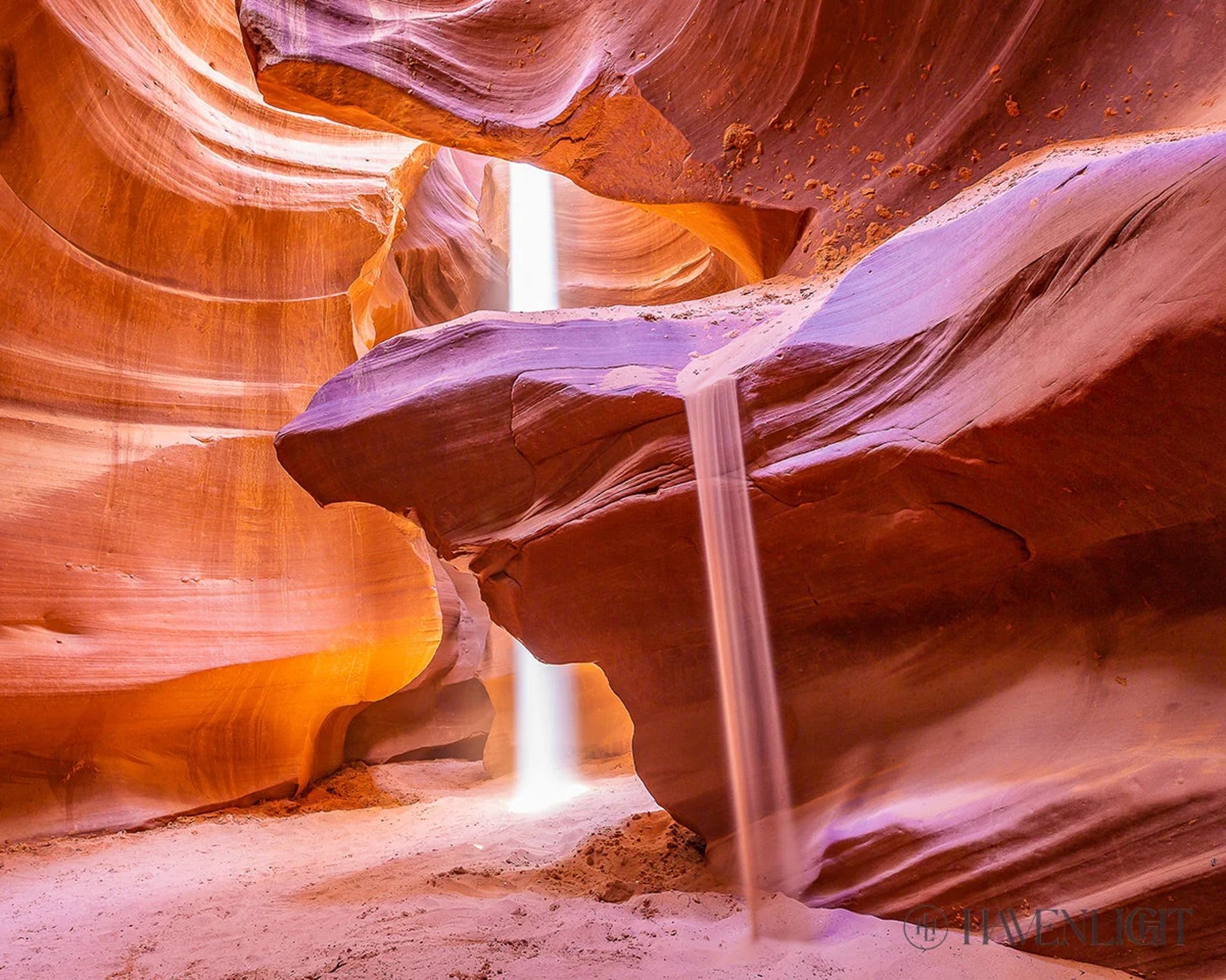
Stop 7: Antelope Canyon (Page, AZ)
Activity: Guided tour through the world-famous slot canyon.
Geological Feature: Antelope Canyon was formed by flash floods carving through Navajo Sandstone. Over time, the flowing water sculpted the rock into smooth, flowing curves and narrow passageways. The vibrant red and orange hues are due to iron oxide minerals present in the sandstone. Light beams shining into the canyon create otherworldly visuals, making this one of the most photographed slot canyons in the world.
Stop 8: Jacob Lake, AZ
Activity: Gateway to the Kaibab National Forest and the North Rim of the Grand Canyon.
Geological Feature: The Kaibab Plateau is composed of limestone, sandstone, and shale from ancient seas that once covered this region. The area sits over 1,000 feet higher than the Grand Canyon’s South Rim, making it a cooler, forested escape in the high desert.
Stop 9: Water Canyon Winery (Hildale, UT)
Activity: Sample locally made wines in a desert oasis.
Geological Feature: Hildale sits near Water Canyon, a region known for its towering red rock cliffs and desert springs. The geology here is similar to nearby Zion National Park, featuring Navajo Sandstone cliffs, slot canyons, and rock arches formed by millions of years of erosion and uplift.
Final Stop: Virgin, UT (Return Home)
Geological Feature: As you return to Virgin, you’ll pass through various rock layers that tell the story of millions of years of geological change. From the ancient deserts of Navajo Sandstone to the deep river canyons carved by water, this trip showcases the power of nature in shaping the landscape of the American Southwest.
Final Thoughts:
This Southwest road trip takes you through some of the most spectacular geological formations in the region. From slot canyons to hoodoos, river bends, and sandstone caves, every stop showcases the incredible forces of erosion, tectonic activity, and ancient sedimentary deposits that have shaped this land for hundreds of millions of years. Whether you're hiking, photographing, or just admiring the scenery, you’ll walk away with a deeper appreciation for Earth’s ever-changing landscapes.
2 DAy ROAD TRIP Includes Stops At
Bryce Canyon / Petrified Forest / Moon Overlook /
Kolob Canyon / Bentonite Hills
2 Day Bryce Canyon Road Trip
This scenic road trip through Utah takes you deep into the ancient rock formations, fossilized landscapes, and dramatic canyons of the Southwest. From towering hoodoos in Bryce Canyon to the multicolored Bentonite Hills, this journey showcases hundreds of millions of years of geological history in just a few days.
Route Overview:
Total Distance: ~600 miles round-trip
Best Time to Go: Spring and Fall (mild weather, fewer crowds)
Best For: Hikers, geologists, photographers, and adventure seekers looking to explore Utah’s stunning rock formations and fossil-rich landscapes.
Stop 1: Virgin, UT (Starting Point)
Geological Feature: Virgin sits within the Colorado Plateau, a massive region of layered sedimentary rock that has been uplifted over millions of years. The red rock formations in this area are primarily Navajo Sandstone, a remnant of ancient sand dunes from the Jurassic period (~180 million years ago).
Stop 2: Bryce Canyon National Park, UT
Activity: Hike among iconic hoodoos in one of the most unique landscapes on Earth.
Geological Feature: Bryce Canyon is famous for its hoodoos—tall, thin spires of rock formed by frost-wedging and erosion. These formations are primarily made of Claron Formation limestone, deposited around 50 million years ago in an ancient lake environment. The distinct red, orange, and white colors are due to iron and manganese oxides in the rock.
Must-See: Navajo Loop Trail, Queens Garden Trail, Inspiration Point
Stop 3: Escalante Petrified Forest State Park
Activity: Hike among petrified wood and ancient fossilized trees.
Geological Feature: This park is home to Jurassic-era petrified wood, which is fossilized remains of trees from 135–150 million years ago. The wood was buried by sediment, and over time, minerals replaced the organic material, turning it into colorful quartz.
Bonus: Some logs contain opal and agate, making them incredibly vibrant under sunlight.
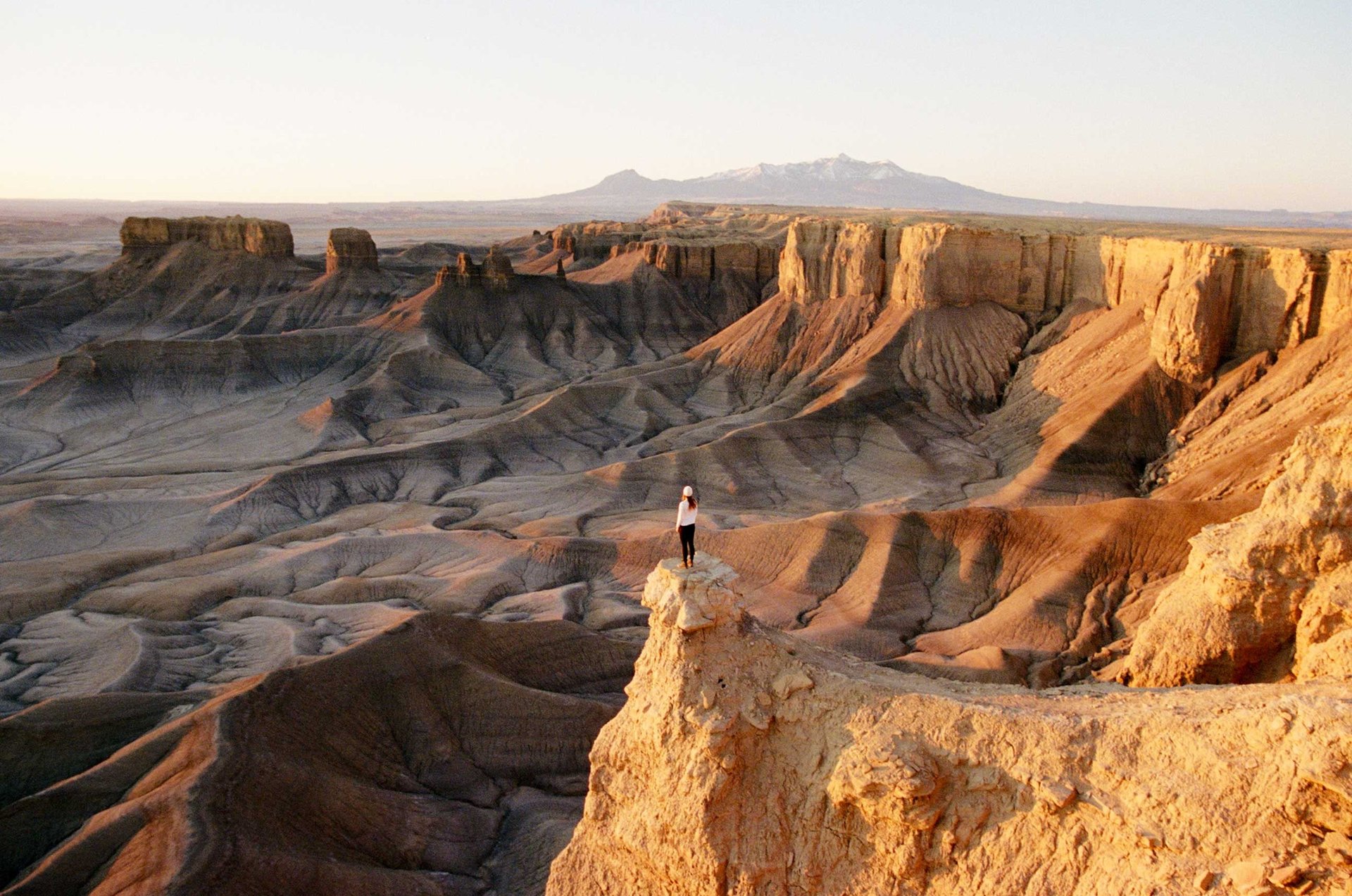
Stop 4: Bentonite Hills, UT
Activity: Drive through a Martian-like landscape of multicolored hills.
Geological Feature: The Bentonite Hills are composed of Morrison Formation clay-rich sediments, deposited around 150 million years ago. The vibrant reds, purples, and grays come from different volcanic ash layers, which were later compacted and chemically altered. The soft texture of the rock makes it highly prone to erosion, creating a surreal, undulating landscape.
Stop 5: Hanksville, UT
Activity: A remote town near some of Utah’s most dramatic badlands and slot canyons.
Geological Feature: Hanksville is surrounded by Mancos Shale and Morrison Formation layers, which hold numerous dinosaur fossils. The landscape was shaped by ancient rivers and seas, leaving behind deeply eroded cliffs and badlands. Nearby areas, like Factory Butte, showcase sharp ridges and barren desert formations, formed by millions of years of wind and water erosion.
Stop 6: Capitol Reef National Park
Activity: Explore deep canyons, domes, and towering monoliths.
Geological Feature: The park is home to the Waterpocket Fold, a 100-mile-long monocline (a type of fold in the Earth's crust where rock layers are uplifted). This massive geologic feature was created 50–70 million years ago during the Laramide Orogeny, a mountain-building event. The park also features Navajo Sandstone cliffs, Entrada Sandstone domes, and ancient petroglyphs.
Must-See: Hickman Bridge, Cathedral Valley, Goosenecks Overlook
Stop 7: Fremont Indian State Park and Museum
Activity: Learn about prehistoric rock art and petroglyphs.
Geological Feature: This park preserves rock art from the Fremont people (A.D. 300–1300), who carved petroglyphs into Claron Formation limestone and sandstone. These rock layers were once ancient lake deposits, later uplifted and eroded over time. The intricate petroglyphs are a window into the lives of the region’s early inhabitants.
Stop 8: Kolob Canyons, Zion National Park (Near E. Kolob Canyon Rd.)
Activity: A less crowded section of Zion featuring deep canyons and towering cliffs.
Geological Feature: Kolob Canyons is made up of deeply eroded Navajo Sandstone cliffs, shaped by millions of years of water erosion and uplift. The massive vertical walls expose ancient sand dunes that have been compacted into rock. Over time, faulting and erosion have carved dramatic slot canyons and towering monoliths in this region.
Final Stop: Virgin, UT (Return Home)
Geological Feature: As you return to Virgin, you’ll pass through various rock layers from different geological eras, including the Jurassic Navajo Sandstone, Triassic Chinle Formation, and Cretaceous Dakota Sandstone—each layer revealing a different chapter in Utah’s vast geological history.
Final Thoughts:
This incredible road trip takes you through some of the most geologically significant landscapes in Utah. From the ancient petrified forests and colorful Bentonite Hills to the massive monoclines of Capitol Reef and towering hoodoos of Bryce Canyon, this journey offers a firsthand look at Earth’s history over millions of years. Whether you’re hiking, photographing, or just exploring, every stop along the way tells a unique story of time, erosion, and natural wonder.
Contact Nick
NickWEAVER44@gmail.com